Parish Walk
Millenium Trail
Kingsclere's Millennium Trail is actually two easy walks that take in many of the noteworthy features of the village and surrounding countryside. Trail A heads south from the village square and out into the fields, while Trail B is a tour of many village houses and architectural highlights. For more information see the Millennium Trail Notes.
Walk Around Kingsclere
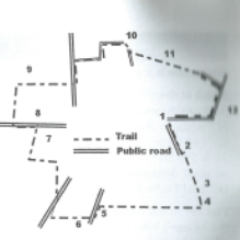
1 1/2 miles, easy walking. Some parts can be muddy after wet weather. Buy the Kingsclere footpath map: £1.50 in local shops or at the Parish Office.
Start in the Square (1). Walk up Anchor Road past the newsagents to the top of the hill, and through the short path at the top of the track. Turn left and onto the Recreation Ground (2). Turn right and walk up the field between the play areas and hedge. At the south end is the ancient wild flower meadow (3) which is one of Hampshire's Treasures and home to cowslips, orchids and other wildflowers. See the information board.
Through the kissing gate and down Shepherds Steps to Hollowshot Lane (4). Opposite the bottom of the steps are Phaleron Cottages, named after a famous racehorse trained at Park House Stables in the valley. Walk west along Hollowshot Lane until you reach the road and turn left towards the stables (5).
At a gap in the roadside hedge cross the road to the lane leading to Gailey Mill (6), built on the site of the first Kingsclere Mill. The name Gailey (originally gale) comes from the Saxon word 'gagle' (myrtle, a shrub used to flavour beer and also called sweet gale).
Follow the path along Gailey Brook and over the bridge. Cross the stile and follow the path between a hedge and fence: over a second stile to the crossroads. Walk along Foxs Lane and take the track (footpath sign) onto Foxs Farm (the old chicken farm) (7). Follow the path round the fence to the road by the Burial Ground (8). Turn left.
After one field, there is a stile with a footpath sign. Follow the hedge northward to the next stile leading to Broad Meadow (9). Now arable, this was the ancient hay meadow for Kingsclere. Follow the hedge back towards the village, through a kissing gate and down Frogs Hole beside the stream to Newbury Road.
Turn left and then right into Longcroft Road and follow the road round to the Limes. Take the path in from of the houses and then follow the paved path across the meadows between a high fence and a hedge (10).
Cross the end of North Street and follow the paved footpath forking right into Love Lane. This is a sunken lane which used to give carts access to the fields. At the main road turn right past the George and Horn and back down George Street to the Square.


